

El Niño is a natural phenomenon that happens every few years, when the surface waters in the Pacific Ocean, along the equator stretching from South America and most of the way across the Pacific, become warmer than usual compared to historical standards.
“When that warming exceeds half a degree, an El Niño is considered to be present, but El Niños come in a range of strengths,” said Research Scientist Bill Merryfield, from the Climate Modelling Research Division of Environment and Climate Change Canada’s Science and Technology Branch.
When warming exceeds two degrees, Merryfield added, it’s classified as a very strong El Niño or what’s sometimes called a super El Niño.
“That’s what’s happening right now. These very strong El Niños, in recent decades, there have been three of them previously going back to the early 1980s. They’ve typically been occurring about once every 10 to 20 years, but this one looks like it’s in a class of its own and will likely be stronger than anything that’s been observed in the lifetime of anyone living today,” Merryfield noted. “Even two degrees of warming of the surface ocean down by the equator, that’s pretty far and doesn’t sound like much, but it actually can have very major impacts rearranging the circulation of the atmosphere.”
One impact is the scrambling of seasonal weather patterns all around the world, including in Canada.
According to Merryfield, El Niño usually starts building in late spring to early summer.
“That’s certainly the case for this one. It usually peaks right around the end of the year, so there are already major impacts in other regions of the world. The tropics are experiencing severe droughts or greatly increased rainfall.”
Main effect in Canada
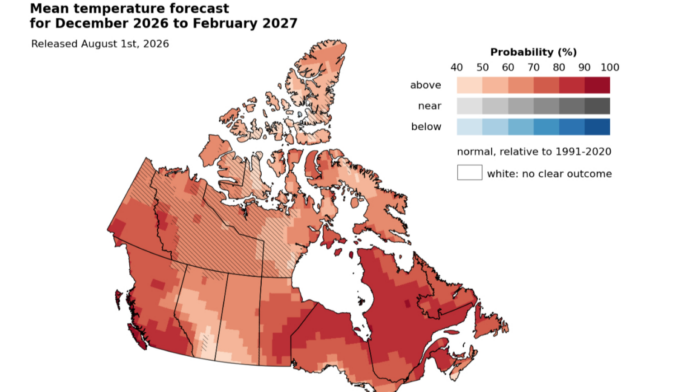
In Canada, the main effects usually don’t set in until right around the end of the year near late December and into the winter months.
“In Western Canada, particularly in British Columbia and Alberta, these can linger well into spring. The main influence that’s most likely to be realized is having milder than usual winter and spring temperatures,” Merryfield explained. “The degree to which that happens depends on a couple of things. One is the strength of the El Niño, and the other is there’s also other influences on climate during the winter that can sometimes appear as wild cards.”
As a rule of thumb, the stronger the El Niño, the stronger this mild influence on Canadian winter temperatures is.
Merryfield said the influence of the last three very strong El Niños stretched all the way from the West Coast to the East Coast.
“On the Prairies, average winter temperatures were somewhere in the range of two degrees to five degrees above normal seasonal values,” noted Merryfield. “It’s a certainty we’ll have one of these super El Niños. It’s influences on Canada are a little less certain. Sometimes nature throws in a curve ball, but the odds are certainly favouring a very mild winter.”
Less snow?
Another little less pronounced impact, Merryfield added, is to have less winter precipitation than usual over the Rocky Mountain region.
“If you add these two things together, mild temperatures and less than usual precipitation, that’s pointing toward a possibility of unusually low snowpack and also an early spring melt.”
Merryfield noted this combination would tend to reduce stream flows coming off of the Rocky Mountains in the late spring and summer months.
Bringing on the heat
El Niño pours great amounts of heat that have been stored in the ocean back into the atmosphere.
“That accumulates over the lifetime of the El Niño. It’s a little bit like having the furnace on. When it comes on, it gets warmer and warmer until it shuts off. We expect this El Niño to dissipate sometime next spring,” Merryfield explained. “One result of this pouring of heat into the atmosphere is we do expect 2027 to set a new record, in terms of the warmest global temperature ever recorded. Breaking the old record, which was set on the heels of a much less El Niño in 2024.”
More information is available online.
Written by: Stan Ashbee – Vista Radio